| LocationPosizioneLage | ~1 hour northeast of Lake Bolsena~1 ora a nord-est del Lago di BolsenaCa. 1 Stunde nordöstlich des Bolsenasees |
|---|---|
| ElevationAltitudineHöhe | 443 m, built on a tuff plateau443 m, su un altopiano di tufo443 m, auf einem Tuffsteinplateau |
| Permanent residentsResidenti stabiliDauerhafte Einwohner | About 11Circa 11Ca. 11 |
| AccessAccessoZugang | Pedestrian footbridge only (no cars)Solo ponte pedonale (niente auto)Nur über eine Fußgängerbrücke (keine Autos) |
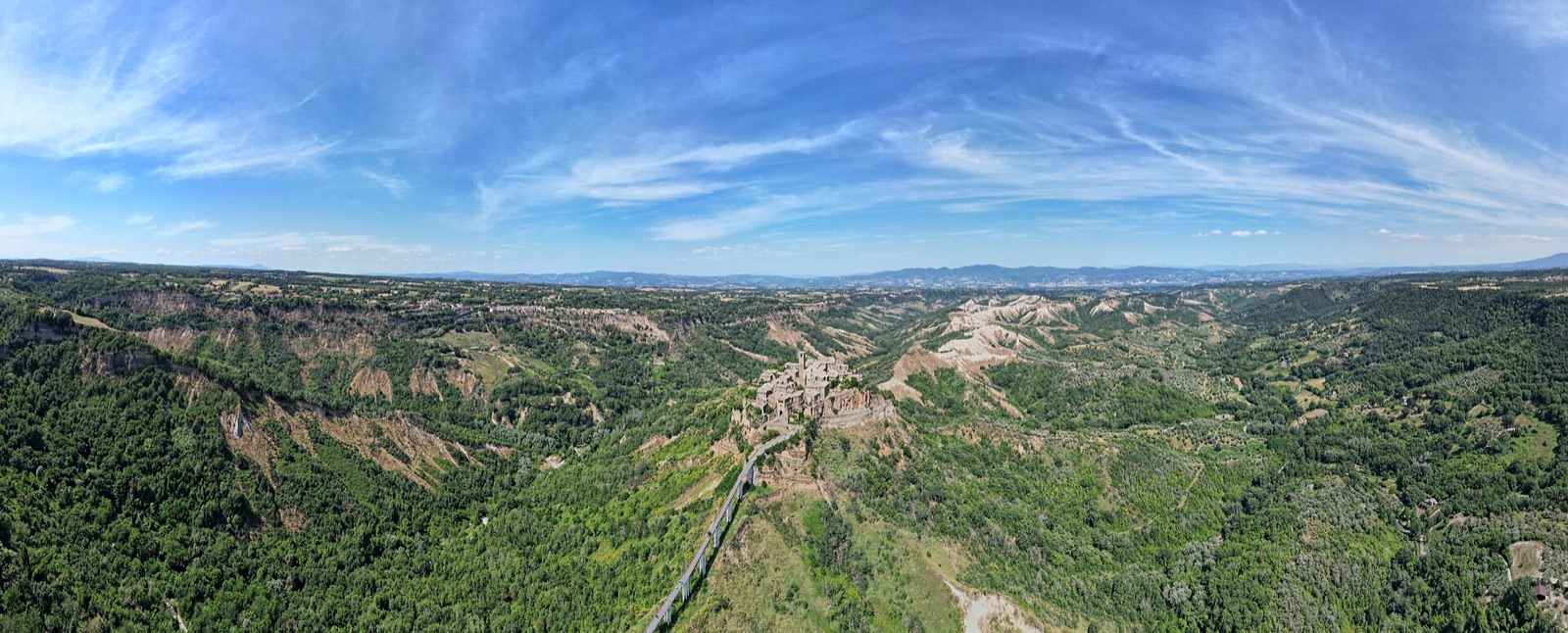
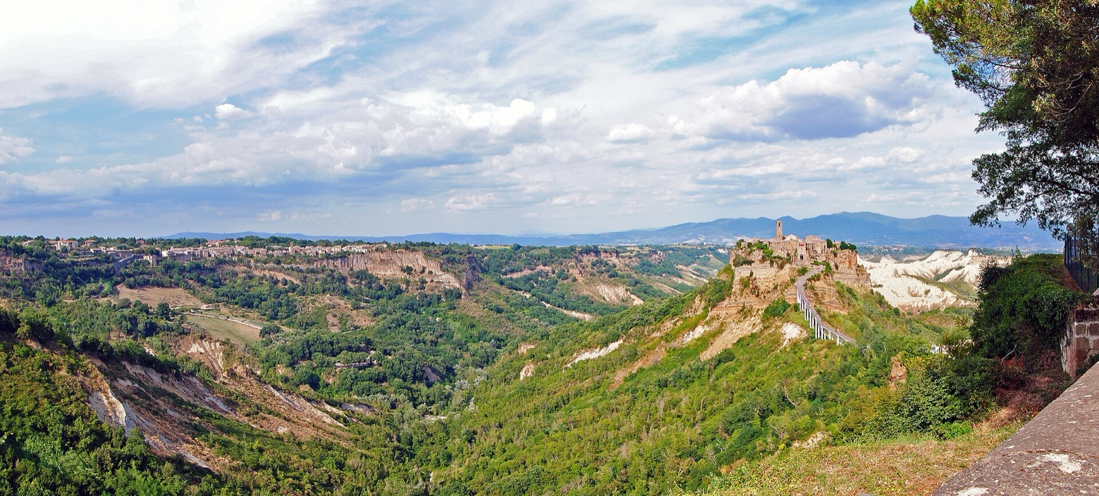
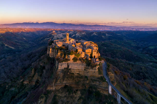
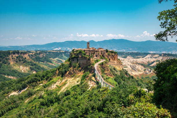
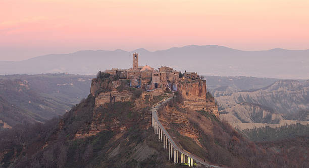
Civita di Bagnoregio sits atop a 443-metre tuff rock relentlessly eaten away by erosion on every side. Known as the "dying city" (la città che muore), it is linked to modern Bagnoregio only by a narrow pedestrian bridge — historically the single lifeline to the outside world, and one that frequently crumbled.
The new bridge built in 1965 paradoxically accelerated the village's decline: many residents used it merely to carry away their belongings and start a new life elsewhere. Today only about 11 permanent residents remain, though peak season draws thousands of visitors from around the world.
Italian engineering keeps the village alive: seven structural shafts, up to 20 metres deep with horizontal tunnels and long tie-rods, stabilise the eroding cliffs, and a geologist monitors the site daily. Below stretches the Valle dei Calanchi, a dramatic erosion landscape shaped over more than a million years — once a seabed, now crossed by guided slow-tourism hikes.
Civita di Bagnoregio sorge su una rupe di tufo di 443 metri, erosa senza tregua da ogni lato. Conosciuta come la "città che muore", è collegata alla moderna Bagnoregio solo da uno stretto ponte pedonale — storicamente l'unico legame con il mondo esterno, e spesso franato.
Il nuovo ponte del 1965 accelerò paradossalmente il declino del borgo: molti abitanti lo usarono solo per portare via le proprie cose e ricominciare altrove. Oggi restano circa 11 residenti stabili, anche se l'alta stagione attira migliaia di visitatori da tutto il mondo.
L'ingegneria italiana tiene in vita il borgo: sette pozzi strutturali, profondi fino a 20 metri con gallerie orizzontali e lunghi tiranti, stabilizzano le rupi in erosione, e un geologo controlla il sito ogni giorno. Sotto si stende la Valle dei Calanchi, un drammatico paesaggio di erosione modellato in oltre un milione di anni — un tempo fondale marino, oggi percorso da escursioni guidate di turismo lento.
Civita di Bagnoregio thront auf einem 443 Meter hohen Tuffsteinfelsen, der von allen Seiten unerbittlich von der Erosion zerfressen wird. Als „sterbende Stadt" (la città che muore) bekannt, ist sie nur über eine schmale Fußgängerbrücke mit dem modernen Bagnoregio verbunden — historisch die einzige Nabelschnur zur Außenwelt, die jedoch häufig bröckelte.
Die 1965 errichtete neue Brücke beschleunigte paradoxerweise den Niedergang des Dorfes: Viele Bewohner nutzten sie lediglich, um ihre Sachen fortzuschaffen und anderswo neu zu beginnen. Heute leben nur noch etwa 11 Dauereinwohner hier, obwohl die Hochsaison Tausende Besucher aus aller Welt anzieht.
Italienische Ingenieurskunst hält das Dorf am Leben: Sieben Brunnenschächte, bis zu 20 Meter tief mit horizontalen Stollen und langen Zugstangen, stabilisieren die erodierenden Klippen, und ein Geologe überwacht das Gelände täglich. Unterhalb erstreckt sich das Kalankital (Valle dei Calanchi), eine dramatische Erosionslandschaft, über mehr als eine Million Jahre geformt — einst Meeresboden, heute von geführten Slow-Tourism-Wanderungen durchzogen.
HighlightsPunti salientiHighlights
- Pedestrian Bridge - The only access point to the isolated town
- Piazza San Donato - Main square with the Romanesque Church of San Donato
- Ancient Stone Houses - Featuring characteristic external staircases (profferli)
- Etruscan Caves - Ancient chambers carved into the tufa rock
- Panoramic Views - Breathtaking vistas of the surrounding eroded landscape
- Ponte pedonale – unico accesso al borgo isolato
- Piazza San Donato – piazza principale con la chiesa romanica di San Donato
- Antiche case in pietra – con le caratteristiche scale esterne (profferli)
- Grotte etrusche – camere antiche scavate nel tufo
- Vedute panoramiche – panorami mozzafiato sul paesaggio eroso
- Fußgängerbrücke – der einzige Zugang zum abgeschiedenen Ort
- Piazza San Donato – Hauptplatz mit der romanischen Kirche San Donato
- Alte Steinhäuser – mit den typischen Außentreppen (profferli)
- Etruskische Grotten – in den Tuffstein gehauene Kammern
- Panoramablicke – atemberaubende Ausblicke auf die erodierte Landschaft
GalleryGalleriaGalerie
Insider tip: Consiglio dell'esperto: Insider-Tipp: Book a guided hike through the Calanchi with local geologists and naturalists. The small museum in Civita shows photos and exhibits of life before the exodus.Prenota un'escursione guidata nei Calanchi con geologi e naturalisti locali. Il piccolo museo di Civita espone foto e reperti sulla vita prima dell'esodo.Eine geführte Wanderung durch das Kalankital mit lokalen Geologen und Naturkundlern buchen. Das kleine Museum in der Civita zeigt Fotos und Exponate über das Leben vor dem Exodus.
Join the Lazio Expats communityUnisciti alla community Lazio ExpatsTritt der Lazio-Expats-Community bei
Connect with fellow travelers and expats in Lazio. Share tips, hidden gems, local events and meetups — all in our friendly WhatsApp group.
Entra in contatto con viaggiatori ed espatriati nel Lazio. Condividi consigli, luoghi segreti, eventi locali e incontri — tutto nel nostro gruppo WhatsApp.
Vernetze dich mit Reisenden und Expats im Latium. Teile Tipps, Geheimtipps, lokale Events und Treffen — alles in unserer freundlichen WhatsApp-Gruppe.
Join on WhatsAppUnisciti su WhatsAppBei WhatsApp beitreten
Lazio Expats
Scan to join the group
Scansiona per unirti al gruppo
Scannen, um beizutreten